Back Poensjak Djaia Afrikaans ፐንቻክ ጃያ Amharic بونتشاك جايا Arabic جبل بونتشاك جايا ARZ Jaya AST Caya dağı Azerbaijani Puncak Jaya BAN Джая Byelorussian Пунчак-Джая BE-X-OLD Джая Bulgarian
You can help expand this article with text translated from the corresponding article in French. (September 2020) Click [show] for important translation instructions.
|
| Puncak Jaya | |
|---|---|
| Carstensz Pyramid / Nemangkawi Ninggok | |
 Summit of Puncak Jaya seen from a Helicopter (c. 2020) | |
| Highest point | |
| Elevation | 4,884 m (16,024 ft)[1] |
| Prominence | 4,884 m (16,024 ft) Ranked 9th |
| Listing | Seven Summits Eight Summits Country highpoint Ultra-prominent peak Ribu |
| Coordinates | 04°04′44″S 137°9′30″E / 4.07889°S 137.15833°E |
| Geography | |
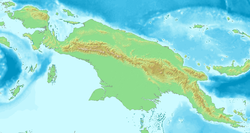
| Location | Central Papua, Indonesia |
| Parent range | Sudirman Range |
| Climbing | |
| First ascent | 1936 by Colijn, Dozy, and Wissels 1962 by Harrer, Temple, Kippax, and Huizenga |
| Easiest route | rock/snow/ice climb |

Puncak Jaya (Indonesian: [ˈpuntʃak ˈdʒaja]; literally "Glorious Peak", Amungme: Nemangkawi Ninggok)[2] or Carstensz Pyramid (/ˈkɑːrstəns/, Indonesian: Piramida Carstensz, Dutch: Carstenszpiramide) on the island of New Guinea, with an elevation of 4,884 m (16,024 ft), is the highest mountain peak of an island on Earth, the highest peak in Indonesia, and the 8th highest mountain in Southeast Asia, on account of Indonesia being part of Asia. The mountain is located in the Sudirman Range of the highlands of Mimika Regency, Central Papua, Indonesia. Puncak Jaya is ranked 5th by topographic isolation.
The massive, open cut Grasberg gold and copper mine, the world's second-largest gold mine, is four kilometres (2+1⁄2 miles) west of Puncak Jaya.
Other summits are East Carstensz Peak (4,808 m [15,774 ft]), Sumantri (4,870 m [15,980 ft]) and Ngga Pulu (4,863 m [15,955 ft]). Other names include Nemangkawi in the Amungkal language, Carstensz Toppen and Gunung Soekarno.[3] It is also the highest point between the Himalayas and the Andes. Some sources claim Papua New Guinea's Mt Wilhelm, 4,509 m (14,793 ft), as the highest mountain peak in Oceania.[4]
- ^ The elevation given here was determined by the 1971–73 Australian Universities' Expedition and is supported by the Seven Summits authorities and modern high resolution radar data. An older but still often quoted elevation of 5,030 metres (16,503 ft) is obsolete.
- ^ Müller, Kal (2008). Amungme : tradition and change in the highlands of Papua. Freeport Indonesia. OCLC 316516243.
- ^ Greater Atlas of the World, Mladinska knjiga, Ljubljana, Slovenia, 1986.
- ^ Statistical Yearbook of Croatia, 2007
© MMXXIII Rich X Search. We shall prevail. All rights reserved. Rich X Search


